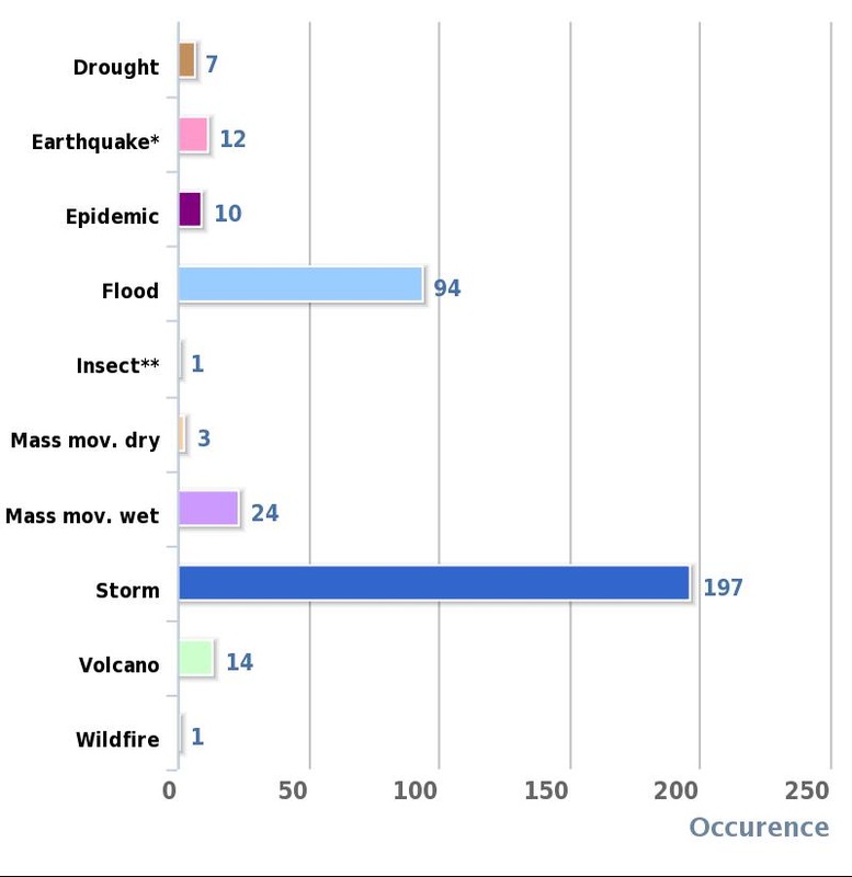
This Graph shows the number of disasters per year in the USA.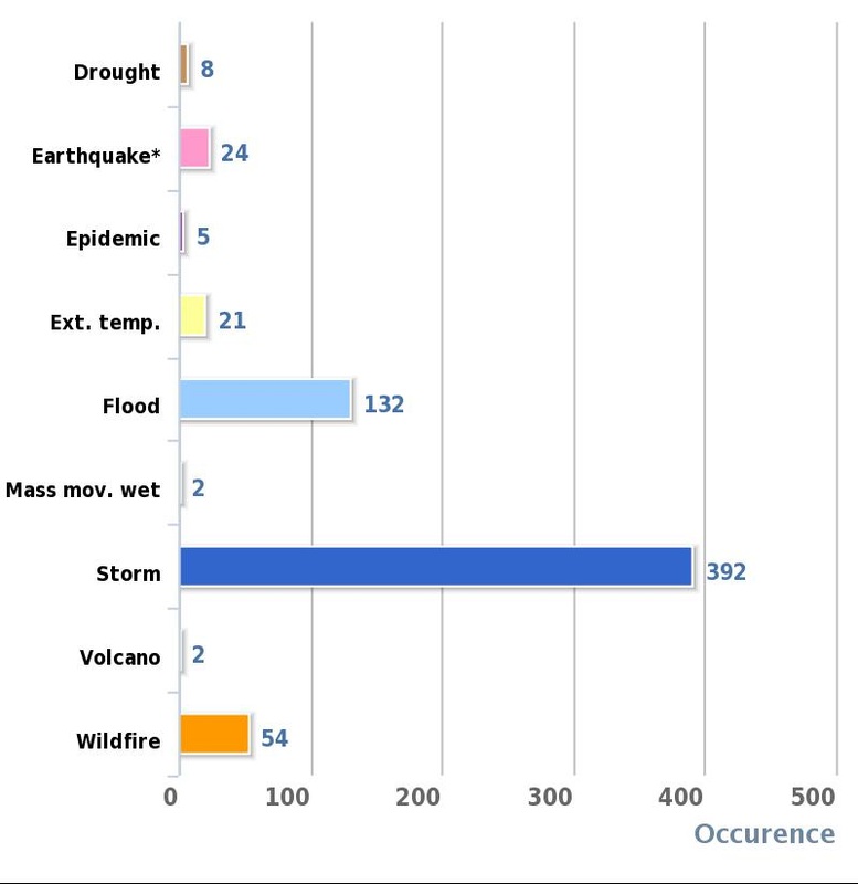
|
|
CASE STUDY FOR MULTIPLE HAZARDS; LOS ANGELES, CALIFORNIA, USA.
For many years, Southern California was America’s “Promised Land”, an ideal fuelled by the warm sunshine, golden beaches, and the mystery, glamour and romance of the film industry. Now it seems that the state is cursed by natural disasters, and Los Angeles, with its 13 million inhabitants, has become known as ‘hazard city’. The summary diagram has explained the interrelationships between the hazards which threaten Los Angeles, but it is necessary to give some more detail about how they affect the daily life of the residents of LA.
PHYSICAL HAZARDS: Earthquakes;
· Not only does the San Andreas Fault, marking the conservative margin between the Pacific and North American plates, cross Southern California, but LA was built across a myriad of transform faults. These include the Santa Monica fault, the San Fernando fault, and the Northridge/Santa Barbara fault.
· Although the most violent earthquakes are predicted to occur along the San Andreas fault, earth movements frequently occur along most of the lesser known faults.
· The most recent of 11 earthquakes to affect LA since 1970 occurred in January 1994, focusing in the Northridge area.
· It registered 6.7 on the Richter scale, lasted for 30 seconds, and was followed by aftershocks lasting several days.
· The quake killed 60 people, injured several thousand, caused buildings and sections of freeway to collapse, ignited fires following a gas leak and explosion in the Granada Hills area, and left 500 000 homes without power and 200 000 homes without water supplies.
· The commonly held public response is of indifference or apathy. Many understand the risks, but feel that it will not happen to them.
· There is no political will to fund complete universal structural improvements, since the tax raise required to fund the development would be tantamount to political suicide.
· What can be done at a local government level is to legislate for new buildings and developments. All new high rise buildings must be designed to withstand earthquakes. This is often done by the company that owns the building, so reducing public expenditure.
· The city government has action plans in place to deal with the immediate and after effects of an earthquake.
· They have also had to fund the structural improvements to major public structures, e.g. highways.
· The responsibility for information and advice presentation during earthquakes has largely fallen upon the media, which was successfully used in 1994. They have drawn up action plans to minimise damages and broadcast disruption.
· Gas, water, and electricity have put in place high technology measures in order to minimise damage to supplies, but the cost of this has been passed on to the consumer.
Tsunamis;
· Tsunamis are large tidal waves triggered by submarine earthquakes, which can travel across whole oceans at great speeds.
· The 1964 Alaskan earthquake caused considerable damage in several Californian regions.
· Although LA has escaped so far, it is considered to be a tsunami hazard prone area, particularly when the numbers and locations of some of the faults are considered.
Coastal Subsidence;
· The threat of coastal flooding has increased measurably due to crustal subsidence.
· Although this may in part be due to tectonic processes, the main cause has been the extraction of oil, and to a lesser extent, subterranean water.
· Parts of Long Beach have sunk by up to 10m since 1926. Although this sinking has now been checked, parts of the harbour area lie below sea level, and are protected from flooding by a large sea wall.
Landslides and Mudflows;
· Landslides and mudflows are a result of the interactions of many hazards.
· They can be caused by earthquakes, heavy rain, deforestation and fires, or over urbanisation. They can even be caused by water seepage from domestic supply and usage.
· They have been increased in frequency by the effects of urbanisation, e.g. deforestation, cutting roads through steep hillsides, and artificially channelling rivers.
· The media is probably one of the most reliable forms of evidence for the landslides each year.
· Landslides and mudflows can destroy houses, as whole hillsides may collapse and if people are in the vicinity, the speed of the event may catch them unaware resulting in injury or even death.
· Most people feel that they have little control over the occurrence of landslides, therefore the majority of the responsibility falls on the city government and building companies.
· It is rare for soil stabilisation to be carried out due to its expense, so mostly this is privately funded.
· The response of the city government has been to restrict development on steep slopes and other risky areas and have therefore carried out risk analysis of many areas.
Heavy Rain;
· Winter storms bring rain and strong winds. These are especially severe during an El Nino event.
· Although most rivers in the LA basin are short in length, and seasonal, they can transport large volumes of water during times of flood.
· Deforestation and brush fires on the steep surrounding hillsides and rapid urbanisation have increased surface runoff.
· Large dams have been built to try and hold back floodwater, but even so, the flood risk remains.
· In February 1992, during an El Nino event, eight people died and dozens of cars and caravans were swept out to sea when, following two days of torrential rain, floodwaters poured through a caravan park south of Malibu.
· Heavy rain also triggers landslides and mudflows.
El NiÔo and La NiÔa Events;
El Nino events seem to coincide with years of above average rainfall, and La Nina events with periods of drought, though to a lesser extent.
· In February 1998, parts of Southern California were declared a disaster area.
· El Nino was blamed for the serious floods, mudflows, landslides, storms, and, in the mountains, heavy snowfalls.
Drought;
· The long dry summers associated with the Mediterranean climate of LA may be ideal for tourists, but, as the population of LA continues to grow, they put tremendous pressure on the limited water supplies.
· Much of the city’s water supplies comes via the Colorado aqueduct from the River Colorado 400 km to the East, or the Owens Valley reservoir via the California Aqueduct.
· The pressure on the water supplies will be intensified after the decision of Arizona to retain all of its’ Colorado allocation from 1996 onwards. Previously, Southern California had been able to use the surplus from Arizona’s requirements.
· LA has one of the highest per capita water consumption rates in the country. During drought periods, wardens have the power to impose fines for wasteful uses of water.
· The new Eastside reservoir projects should double the surface water storage capacity of the state, which will be used by both LA and San Diego.
· So much river is taken from the Colorado that it almost dries up before reaching the sea, in years of drought.
Brush fires;
· Much of the Los Angeles basin is covered in xerophytic (drought resistant) chaparral, or brush vegetation.
· By the autumn, after six months without rain, this vegetation is tinder dry.
· The Santa Ana is a hot, dry wind that owes its high temperature to adiabatic heating as it descends from the mountains.
· The heat and extreme low humidity of the Santa Ana cause discomfort to humans and increase the dryness of the vegetation.
· In these conditions, a careless spark or an electrical storm can cause serious fires.
· In September 1970 a fire, 56 km in width, swept down from the Santa Monica Mountains in to Malibu.
· Some 72 000 hectares of brush and 295 houses were destroyed and three people died.
· In November 1993, the homes of several film stars were among 1000 destroyed in another severe brush fire.
Fog and Smog;
· Advection fog occurs when cool air from the cold offshore Californian current drifts inland where it meets warm air.
· Fog can form most afternoons between May and October, as the strength of the sea breeze increases.
· This event can cause a temperature inversion, where warm air becomes trapped under colds.
· When pollutants from LA’s traffic, power stations, and industry are released in to the air, they cause smog, and when they return to Earth, acid rain. Pollution is moved inshore by sea breezes.
· Some 1,130 tons of noxious gases, including nitrous oxides, ozone, sulphur dioxides, hydrocarbons and other gases, are emitted in to LA’s atmosphere each day, helped by the 8 million cars on LA’s roads.
· The sunshine helps to produce some of the highest ozone concentrations anywhere in the USA, the effect reaching as far east as San Bernardino.
· The Clean Air Act set up the South Coast Air Quality Management District (SCAQMD) in 1977. It attempts to reduce pollution and enforce anti-pollution regulations, e.g.;
Þ Strict emission levels for vehicles, power plants and industry.
Þ Businesses with over 50 employees must organise car pooling programmes.
Þ Catalytic convertors mandatory on all cars by the year 2000.
Þ Organisations have ‘emission credits’ with targets to reduce the amount of pollutants. Those which meet their targets may sell unused credits to less successful firms. Target levels are gradually reduced over 10 years, forcing a clean up.
· The SCAQMD hopes to reduce the number of petrol using cars by 1 million, and encourage the development and use of overall public transport systems, as yet lacking in LA.
· In 1999, a health maintenance organisation confirmed a correlation between smog and hospital admissions. For each 10 mg increase in airborne particulate concentration, admission jumped 7% for chronic respiratory patients, and 3.5% for cardiovascular patients. According to another recent study, reported in the Los Angeles Times, residents showed lung damage that might be expected of someone who smoked half a pack of cigarettes per day.-
